
|
|||
|
|||
Is The Sierra Club Spying On You? |
WEB SITE CALLED SECRET WEAPON IN BATTLE FOR CONSERVATION Some people go to the beach and come back with a snapshot. Ken Adelman has come back with 7,000 of them. And he isn't finished yet. In an unprecedented marriage of high technology and environmental activism, Adelman, a 39-year-old computer programmer from Santa Cruz County, has taken 7,000 aerial photographs of the California coastline -- one roughly every 500 feet. His quest, which could spell trouble for developers building illegal seawalls or blocking public beach access, is to photograph every inch of the state's 1,100-mile shoreline from Oregon to Mexico. |
|
|
||||||||||||
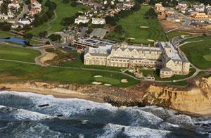
The massive undertaking, which is shot in detail clear enough to see people standing in their back yards, is not an art project, he says, but a carefully focused tool for environmentalists and scientists to fight development, seawalls and other coastal threats. ``Part of the reason for this is to make it available to the public so your average person can see what is being done to the coast and can appreciate it,'' Adelman said. ``People won't conserve what they don't love.'' Although it is only a week old, the site already has received more than 5,000 hits. Photographs featured on it recently became evidence in one dispute in Half Moon Bay. Scientific researchers, government planners and environmental groups are among the first users, and say the site provides invaluable evidence for coastal protection efforts. Anyone who might be curious now has access to see famous landmarks from the Golden Gate Bridge to Santa Monica Pier, and also virtually every beach, cliff and building on the coast. Adelman, who struck it rich selling software companies he co-founded during the Internet boom, owns four electric cars. His Corralitos home boasts the largest residential solar power system in the state. For this pet project, he shot digital pictures from a helicopter that his wife, Gabrielle, flew up and down the coast. He loaded the photos onto the Web site, www.californiacoastline.org, last week and added a map-finder feature. He is donating the photos -- which would take up about 99 CD-ROMS' worth of computer memory -- to environmental groups. Already, one set of images was used by the Sierra Club in arguments before the California Coastal Commission that a golf course developer in Half Moon Bay put hundreds of granite boulders on a public beach without a coastal permit. The Coastal Commission two weeks ago ordered the developer, Ocean Colony Partners, to remove half of the boulders from beach fronting the 18th hole on its old course at Half Moon Bay Golf Links, adjacent to the Ritz Carlton Half Moon Bay. The developer has until Jan. 10 to return with a permit application, and may have to remove all the boulders or face fines up to $6,000 a day. ``We would have taken the action anyway,'' said Nancy Cave, the commission's Northern California enforcement supervisor. ``But the value of a Web site like this is that it provides evidence. We can then go out and independently confirm that evidence.'' Environmentalists believe they have a new secret weapon. ``This is the most fun you can have with a computer,'' said Mark Massara, the Sierra Club's director of California coastal programs. ``We're pleased as punch.'' Massara and other activists have fought the spread of seawalls, arguing that they destroy public beaches and deflect waves, which increases erosion elsewhere along the coast. In recent years, they have battled billionaire moguls, movie stars and other oceanfront residents, telling them not to build their homes so close to the shore. They also have fought landowners who block public paths to the beach. Massara said that clicking through Adelman's Web site he has already seen ``dozens'' of violations of the California Coastal Act. ``No longer are we dependent on developers to tell us what lies on a lot of these parcels,'' he said. Massara said he would like to raise foundation money to digitally photograph the entire U.S. coastline, along with Canada and Mexico, he said. Not everyone is jumping for joy. Ronald Zumbrun, a Sacramento attorney who has represented property owners in fights with the coastal commission, said the new Web site will only cause headaches for coastal landowners. ``My concern when the Sierra Club is going to become vigilantes with these photographs is that there be some fairness to people,'' he said. ``People should not have to prove they are not criminals.'' Zumbrun said there may also be privacy concerns. Courts have generally held, however, that images photographed in plain view from public places can be published without permission. Adelman, a classic Silicon Valley success story, came to California in the late 1980s from Connecticut and founded TGV Software. He sold the Santa Cruz firm to Cisco Systems. He then co-founded another company, Network Alchemy, which made encryption devices, and sold it to Nokia two years ago. With some of the proceeds, he bought the four-seat Robinson R-44 helicopter. Since March, Adelman has zoomed up and down the coast with the doors off the helicopter. Holding a Nikon DX1 digital camera, he snaps hundreds of pictures in a stretch. ``I'm looking through the camera for hours at a time,'' he said. ``It's just click, click, click. If I start falling behind I ask my wife to slow down.'' The camera is linked with a cable to the helicopter's global positioning system, and to an Apple Power Book laptop. Every three seconds, he snaps a picture, and the exact longitude, latitude and altitude are recorded. Adelman said he will spend about $20,000 to photograph the whole coast, and take about 10,000 pictures in all. He has finished about 60 percent, including nearly everything from Marin County to Los Angeles. He expects to finish the rest of Southern California this week. One area, over Vandenberg Air Force Base in Santa Barbara County, is in restricted air space and Adelman is still working to get permission to photograph there. As word of Adelman's project has leaked, scientists have taken notice. Researchers said the photos could be used to measure erosion, beach changes, vegetation changes and development patterns over time. ``This could be very valuable as a snapshot in time for the entire coast of California,'' said Gary Griggs, director of the Institute for Marine Sciences at the University of California-Santa Cruz. Adelman said he hopes to reshoot the coast every two years. He began using aerial photos in 1997 to help environmentalists who were battling plans by the Hearst Corp. to build a golf course and hotels on oceanfront property near Hearst Castle in San Luis Obispo County. His images were made into postcards and posters. After a huge public protest, the Coastal Commission rejected the plan. ``This is an incredible tool. A picture tells a thousand words,'' said Susan Jordan, director of the California Coastal Protection Network, in Santa Barbara. ``This revolutionizes not just coastal advocacy, but also planning. It really raises the bar.''
Contact Paul Rogers at progers@sjmercury.com or (408) 920-5045.
|
|
|||||||||||||||||||||||||||||||||||||||||||||||||||||||||||||||||||||||||||||